IND

Trending Now

earthquake

Earthquake Today: 2.6 Magnitude Quake hits Uttarakhand Uttarkashi.

An earthquake of 2.6 magnitude on the Richter scale hit Uttarakhand’s Uttarkashi on Tuesday.

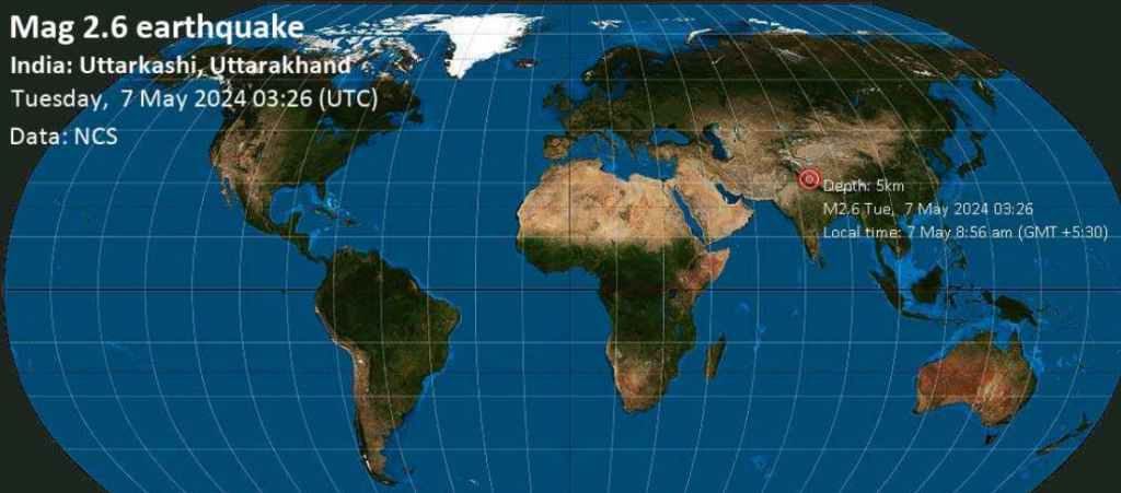
The National Centre for Seismology (NCS) reports that Uttarakhand’s Uttarkashi had an earthquake on Tuesday that had a value of 2.6 on the Richter scale. The epicenter was five kilometers deep and was at latitude 31.0 and longitude 79.31.

The NCS posted on X (previously Twitter) with the following information: “EQ of M: 2.6, On 07/05/2024 08:56:40 IST, Lat: 31.00 N, Long: 79.31 E, Depth: 5 Km, Location: Uttarkashi, Uttarakhand.”

On May 1, Kishtwar in Jammu and Kashmir was struck by an earthquake with a magnitude of 3.4 on the intervening Tuesday and Wednesday nights. The earthquake happened thirty kilometers below the surface.
Also Read: The Third Space Mission of Sunita Williams was Canceled.

EARTHQUAKE DETAILS

Date & Time (UTC)May 7, 2024 03:26:40 UTC – 1 hour 47 minutes ago
Local Time at EpicenterMay 7, 2024, 03:26:40 UTC – 1 hour 47 minutes ago
StatusConfirmed
Magnitude2.6
Depth5 km
Epicenter31°N / 79.31°E Chamoli, Uttarakhand, India
ProximityAlso near China, 11.9 km (7 mi) away
Seismic Antipode31°S / 100.69°W
Shaking IntensityBroken Clouds, -9.4°C (15°F), humidity: 81%, wind: 2 m/s (4 km) from WSW
Felt0 reports
Primary Data SourceNCS (National Center for Seismology)
Weather at EpicenterBroken Clouds, -9.4°C (15°F), humidity: 81%, wind: 2 m/s (4 kts) from WSW
Estimated Seismic Energy5 x 10^8 joules (139 kilowatt hours, equivalent to 0.12 tons of TNT)

Recently, on March 5, two earthquakes with magnitudes of 2.5 and 1.8 struck Uttarkashi.

An earthquake of a magnitude of 3.1 struck the Uttarkashi district on December 28 of last year. Two earthquakes measuring 2.7 and 3.1 were recorded in July of last year in the same district.

An earthquake with a magnitude of 4.1 was recorded in Uttarkashi on April 3 of last year. Three-magnitude earthquakes were detected in the Pithoragarh district that same day. On February 17, an earthquake of a magnitude of 3.3 struck the Chimoli district. Uttarkashi was struck by an earthquake with a magnitude of 4.1 earlier on February 12. A 4.1-magnitude earthquake struck the Uttarkashi district on February 6.

Aftershocks from the 4.8-magnitude earthquake in New Jersey tremble the Philadelphia area!

At first, the aftershock’s magnitude was reported as 4.0. The initial 4.8 magnitude earthquake, which struck at 10:23 a.m. and was centered between the communities of Whitehouse Station, Califon, and Lebanon, was followed throughout the day by some aftershocks. Philadelphia is roughly 60 miles northeast of that region.

April is National Earthquake Preparedness Month: Let’s Get Ready!

WPVI (Philadelphia earthquake) — Less than eight hours after a powerful aftershock struck northern New Jersey, the Philadelphia region was rocked by another one on Friday.

The United States Geological Survey indicated that the aftershock, which was felt at roughly 6 p.m., had a magnitude of 4.8 earthquake and was located close to Gladstone, New Jersey. At first, the aftershock’s magnitude was reported as 4.0.

There have been several aftershocks throughout the day following the original 4.8 earthquake, which happened around 10:23 a.m. and centered between the towns of Whitehouse Station, Califon, and Lebanon. That area is about 60 miles northeast of Philadelphia.

Aftershocks will continue for days and weeks ahead, the USGS said.

The Friday morning quake startled millions of people in a region of the country unaccustomed to such tremors.

The 4.8 magnitude registered by this earthquake is just below what’s considered to be a moderate quake.

The earthquake had a depth of about three miles, the USGS said.

The agency’s figures indicated that over 42 million people might have felt the rumbling.

There are an estimated 13,000 earthquakes in the 4.0 – 4.9 range worldwide every year, according to a chart from Penn State University.

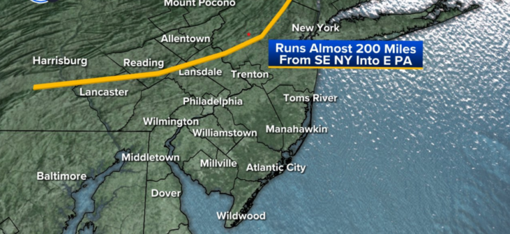
It originated near the Ramapo Fault Line, which extends from near the Hudson River in southeastern New York to just south of Harrisburg, Pennsylvania.

Earthquake rattles New York City, felt in Washington, D.C.

The quake also rattled New York City, but officials there say there have been no major impacts.

The earthquake could be felt as far south as Washington, D.C. and as far north as Maine, according to the U.S. Geological Survey.

While there were no immediate reports of serious damage, officials were checking bridges and other major infrastructure.

What causes an earthquake?

Earthquakes are violent shaking from the planet’s surface, according to AccuWeather. They’re caused by movement from Earth’s outermost layer, the crust.

The crust is broken up into pieces called tectonic plates that are always on the move, though usually in ways we cannot feel.

When the plates hit a roadblock, stress builds and leads to cracks in the Earth called faults.

In time, the energy from within builds to the breaking point. That sudden release leads to an earthquake.

The shaking begins at a central region called the epicenter and spreads far and wide. An earthquake can then be followed by additional shaking known as an aftershock.

What to do after an earthquake

Here are some tips for what to do after an earthquake hits:

  • First, check on yourself on those around you to make sure everyone is okay.
  • Check water, gas, and electric lines for damage
  • If any lines are damaged, shut them off if you can
  • Be alert for more shaking as aftershocks are common after earthquakes

A “Strongest Earthquake In 25 Years” strikes Taiwan, leaving one dead and sixty injured.

Authorities declared that the earthquake and its subsequent powerful aftershocks were the worst to hit the island in decades and issued a warning of additional tremors in the days to come.

A strong earthquake in Taiwan on Wednesday caused damage to dozens of buildings, triggered tsunami warnings that reached to Japan and the Philippines before being lifted, and at least one person was thought to be dead and almost sixty injured. Authorities declared that the earthquake and its subsequent powerful aftershocks were the worst to hit the island in decades and issued a warning of additional tremors in the days to come.

“The earthquake is shallow and occurs near land. The director of Taipei’s Central Weather Administration’s Seismology Center, Wu Chien-fu, stated that the earthquake was felt throughout Taiwan including offshore islands.

Given that the island is located close to the meeting point of two tectonic plates, strict building codes and disaster awareness seem to have prevented a significant tragedy.

Must Read : Big Meech Net Worth 2024!

Wu stated that the earthquake was the strongest since a 7.6-magnitude one that occurred in September 1999, the deadliest natural disaster in the history of the island, killing around 2,400 people.

The United States Geological Survey (USGS) estimated that the epicentre of Wednesday’s magnitude 7.4 earthquake was 34.8 kilometers deep and located 18 kilometers (11 miles) south of Hualien City, Taiwan. The earthquake occurred immediately before 8:00 am local time (0000 GMT).

“I wanted to flee, but I had no clothes on. That was really powerful,” remarked Kelvin Hwang, a visitor to a hotel in Taipei’s capital who sought take cover in the ninth-floor elevator lobby.

Shared videos and pictures of buildings trembling around the nation went viral on social media as soon as the earthquake occurred.

After it ended, dramatic pictures of multi-story buildings in Hualien and other places tilting over were broadcast on local television.

There have been reports of landslides blocking roads leading to Hualien, a 100,000-person coastal city surrounded by mountains.

One person on a hiking trail was reportedly crushed to death by a loose boulder, according to the Central Emergency Operations Center, which also stated that about 60 individuals had received treatment for injuries sustained during the earthquake.

Authorities in Taiwan, Japan, and the Philippines first issued a tsunami warning, however the Pacific Tsunami Warning Center declared that the threat had “largely passed” by around 10 am (0200 GMT).

The metro in the nation’s capital briefly stopped operating but soon resumed, and local borough leaders issued cautions to citizens to check for any gas leaks.

Because Taiwan is located close to the meeting point of two tectonic plates, it is frequently struck by earthquakes; Japan, to the north, receives about 1,500 shockwaves annually.

Social media users in the eastern Chinese province of Fujian, which borders the southern province of Guangdong, as well as other places, reported feeling powerful earthquakes across the Taiwan Strait.

According to state news agency Xinhua, China, which views self-ruled Taiwan as a colony gone wild, was “paying close attention” to the earthquake and “willing to provide disaster relief assistance”.

Even though the bulk of the earthquakes in the region are small, the harm they cause vary depending on the location and depth of the epicenter under the surface of the Earth.

The power of tsunamis, which are enormous, potentially catastrophic waves that can travel hundreds of kilometers per hour, is also dependent on a number of variables.

The largest recorded earthquake in Japan occurred in March 2011 off the northeast coast of the country and measured 9.0 magnitude. The earthquake caused a tsunami that killed or left over 18,500 people missing.

The Fukushima nuclear facility experienced the biggest post-war disaster in Japan and the worst nuclear accident since Chernobyl as a result of the 2011 tragedy, which also caused three reactors to melt down.

Japan saw a major quake on New Year’s Day this year, when a 7.5-magnitude tremor hit the Noto Peninsula and killed more than 230 people, many of them when older buildings collapsed.

Also Read : Elections for the Lok Sabha: Congress fields Tariq Anwar from Katihar and Y S Sharmila Reddy from Kadapa.

A 7.1-magnitude earthquake that struck western China pushed thousands of people from their homes!

Although there was a lot of damage done by the earthquake in the bitter cold, there were not many casualties or losses of property because the epicentre of the earthquake was in Uchturpan County, close to the Kazakhstani border.

 7.1-magnitude earthquake

As aftershocks continued to rock western China on January 24, more than 12,000 people were staying in tents and other shelters, lighting bonfires to fend off the freezing weather.

The previous day, a magnitude 7.1 earthquake in a remote part of China’s Xinjiang region killed three people and left five injured, while damaging hundreds of buildings.

The earthquake caused significant damage amid freezing temperatures, but the toll on lives and property was relatively light, owing to the sparse population around the epicentre in Uchturpan county, near the border with Kazakhstan.

Footage shown by state broadcaster CCTV on January 24 showed evacuees eating instant noodles in tents with bonfires providing heat.

Jian Gewa, a 16-year old student in Uchturpan, said he was in the bathroom when the quake began. The entire building shook violently. “I just thought I had to get myself to safety as quickly as possible,” Jian said.

Read More : Chandigarh AQI ‘very poor’, Administration blames burning of waste on periphery

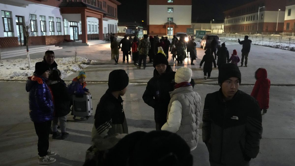
He was evacuated to a school where he was staying in a dorm room with his grandfather, joining about 200 others. Local officials said they planned to check houses’ stability before people could return.

The earthquake hit in a sparsely populated area with clusters of towns and villages scattered across an otherwise barren winter landscape. A two lane highway runs from the city of Aksu about 125 km (78 miles) to the area, through frozen brown flatlands on one side and craggy outcroppings on the other. Power lines and an occasional cement factory are virtually the only signs of human presence.

In Kizilsu Kirgiz prefecture, the earthquake caused damage of various degrees to 851 buildings, collapsing 93 structures near the epicentre and killing 910 livestock, according to the prefecture deputy party secretary Wurouziali Haxihaerbayi.

The area is populated mostly by Kyrgyz and Uyghurs, ethnic Turkic minorities who are predominantly Muslim and have been the target of a state campaign of forced assimilation and mass detention. The region is heavily militarised, and state broadcaster CCTV showed paramilitary troops moving in before dawn to clear rubble and set up tents for those displaced.

The prefecture has deployed more than 2,300 rescuers, and Akqi county evacuated 7,338 residents. In total, 12,426 people have been evacuated. Rescue crews combed through the rubble while emergency survival gear including coats and tents arrived to help the thousands of people who fled their homes.

“This 7.1 rating is very strong, but the death and injury situation is not severe,” Zhang Yongjiu, the head of Xinjiang Earthquake Administration,” told a news conference. The earthquake’s epicentre was in a mountainous area about 3,000 metres (9,800 feet) above sea level, Zhang said.

In the village of Yamansu, about 115 people were staying in a Communist Party meeting hall, their bedding neatly rolled up on Wednesday morning (January 23) on top of five long rows of metal bed frames. Medical staff were on hand to check on older residents.

Read More : India’s first automatic CNG vehicle is introduced by Tata Motors, with reservations starting at low Rs!

A light layer of snow covered the frozen ground as temperatures remained well below freezing, although the sunshine brought people outside. The quake hit shortly after 2 a.m. on January 23. By evening, authorities said three people had died and five were injured, two seriously.

State broadcaster CCTV said 1,104 aftershocks, including five that were above magnitude 5.0, were recorded as of 8 a.m. on January 24. The largest registered at magnitude 5.7. Among the buildings damaged, 47 houses had collapsed, the government of the Xinjiang Uygur Autonomous Region posted on its official Weibo social media account on January 22.

Officials said most of the houses that collapsed were in remote areas and were built by residents. Newer public housing built by the government did not collapse.

Footage broadcast by CCTV showed staff at Aksu’s train station ordering passengers out of the waiting hall in a speedy but not panicked manner.

Some walls were cracked or partially collapsed in the empty Aksu country village of Youkakeyamansu, a name transliterated in Mandarin from Uyghur. All residents had been evacuated to a shelter.

The mountainous Uchturpan county is recording temperatures well below freezing, with the China Meteorological Administration forecasting lows reaching negative 18 degrees Celsius (just below zero Fahrenheit) this week. The county had around 2,33,000 people in 2022, according to Xinjiang authorities.

Read More : Lok Sabha elections 2024: PM Modi is probably going to start his campaign tomorrow from Bulandshahr in Uttar Pradesh!

“The quake downed power lines but electricity was quickly restored,” Aksu authorities said. The Urumqi Railroad Bureau resumed services after 7 a.m. following safety checks that confirmed no problems on train lines. The suspension affected 23 trains, the bureau serving the Xinjiang capital said on its official Weibo account.

The U.S. Geological Survey said the area’s largest quake in the past century was also magnitude 7.1 and occurred in 1978, about 200 km (124 miles) to the north of Tuesday’s epicentre. Tremors were felt hundreds of km (miles) away.

Tremors also were felt in neighbouring Kyrgyzstan and Kazakhstan and reportedly as far away as New Delhi. Videos posted on the Telegram messaging platform showed people in the Kazakh city of Almaty running downstairs in apartment blocks and standing in the street, some of them wearing shorts in the freezing weather.

In Xinjiang and Kazakhstan, classes were suspended to allow children to recover from the shock. Earthquakes are common in western China.

A 6.2 magnitude earthquake that struck Gansu province in December killed 151 people and was China’s deadliest quake in nine years. An earthquake in Sichuan province in 2008 killed nearly 90,000.

“Elsewhere, authorities raised the confirmed death toll to 31 on Tuesday in a landslide in a remote, mountainous part of China’s southwestern province of Yunnan,” Chinese state media reported.

The disaster struck just before 6 a.m. on Monday in the mountain village of Liangshui. Authorities said on Tuesday that a total of 44 people were either missing or had been found dead.

This article is sourced from thehindu!

A 6.1-magnitude earthquake in Afghanistan causes tremors in Delhi and other parts of North India!

The tremors triggered panic among people, with many in the national capital and surrounding areas reported shaking of furnitures!

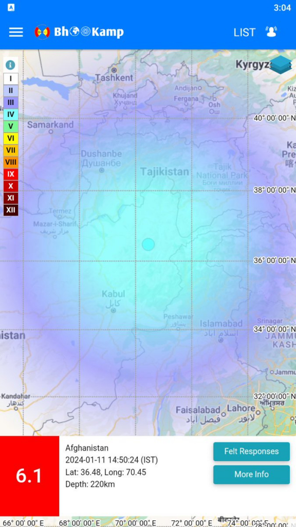
Mild tremors were felt in Delhi and parts of northern India this afternoon after 6.1 magnitude earthquake struck Afghanistan. The tremors were felt even in Pakistan.

“Earthquake of Magnitude:6.1, Occurred on 11-01-2024, 14:50:24 IST, Lat: 36.48 & Long: 70.45, Depth: 220 Km ,Location:  Afghanistan,” said National Center for Seismology in a post on X.

The epicentre for the quake was 241 kilometres of northeast of Kabul, it said.

The tremors triggered panic among people, with many in the national capital and surrounding areas reported shaking of furnitures. The tremors were felt in the national capital. Mild tremors were felt in Delhi and parts of northern India this afternoon after 6.1 magnitude earthquake struck Afghanistan.

This article was originally published on: NDTV.com!

Also Read : Tata Technologies Launches Hiring Campaign Targeting Women On Career Break!